Documenting the Fracturing of a Continent
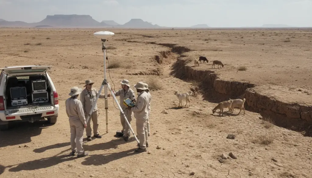
On a sweltering morning within Ethiopia’s Afar Desert, researchers gather quietly around a seemingly mundane metal rod planted in the soil. A GPS antenna sits firmly attached to its peak, silently intercepting signals from spacecraft orbiting thousands of kilometers above. While goats roam freely and the shimmering heat creates optical illusions, the landscape itself feels unyielding and permanent.
Yet, the data displayed on monitors inside a nearby utility vehicle reveals a starkly different reality. The African landmass is progressively stretching and fracturing, millimeter by millimeter, as a nascent ocean slowly begins to form beneath the surface. The most remarkable aspect of this phenomenon is that modern technology allows us to observe this continental fragmentation as it happens.
Initially, the concept feels plucked from a science fiction novel. A massive fissure is gradually tearing Africa into two distinct landmasses, carving a path from the Red Sea southward across Ethiopia, Kenya, Tanzania, and neighboring regions. Geologists refer to this vast geological feature as the East African Rift. From orbital perspectives, it resembles a planetary blemish that deepens and lengthens with each passing year.
At the surface level, observers do not find a single continuous canyon, but rather an intricate network of plunging valleys, active fault lines, and volcanic peaks. The crust simultaneously elevates in certain zones and collapses in others, driven by upwelling hot magma from deep within the mantle.
When Subterranean Tension Reaches the Surface
This typically sluggish geological transformation gained sudden global attention during 2018 when a massive trench abruptly tore through agricultural land near Mai Mahiu in Kenya. Essential roadways crumbled into the void, while wire fences dangled uselessly over the newly formed chasm.
Startling images of the rift circulated rapidly online, drawing crowds of fascinated yet anxious locals to the site. Geoscience professionals quickly clarified that underlying tectonic stress had been accumulating in this exact location for centuries, culminating in this localized surface collapse.
That spectacular ground rupture represents merely a fleeting visible symptom of an evolution spanning millions of years. This tectonic separation usually remains entirely imperceptible to the human eye, advancing at the pace of growing fingernails. To comprehend these hidden dynamics, advanced monitoring tools are essential.
High-precision GPS instruments positioned throughout East Africa document their precise coordinates daily. By processing transmissions from numerous overhead spacecraft using sophisticated algorithms, minuscule geographical displacements become evident over time. Current measurements confirm that specific eastern regions are detaching from the main African plate at a rate of roughly 2 to 7 millimeters annually. Over geological timescales, this microscopic creep ultimately gives rise to entirely new shorelines and oceanic basins.
Utilizing Satellites to Measure Tectonic Creep
The underlying methodology relies on using orbital technology as an incredibly precise measuring tool. Geoscience specialists secure compact GPS receivers deep into stable bedrock. These terrestrial monitors maintain constant communication with a network of satellites situated roughly 20,000 kilometers in space. By analyzing the precise travel time of these orbital signals, analysts can pinpoint earthbound locations with sub-millimeter precision.
Each monitoring station functions as a dynamic marker on a constantly updating map. When adjacent markers gradually drift away from one another, it confirms that the ground is undergoing physical extension. Conversely, when these markers glide past each other, it indicates an active fault line in motion.
While consumer navigation systems help commuters locate local businesses in Cape Town or Nairobi, this sophisticated scientific equivalent monitors subtle ground swelling before volcanic eruptions. In regions like the Afar depression, radar surveillance and terrestrial receivers perfectly map how the terrain warps under the pressure of rising magma.
A prominent illustration of these capabilities occurred during the 2005 Dabbahu rifting sequence. Over a span of merely a few days, an extensive 60-kilometer fracture tore through the arid terrain as molten rock aggressively wedged its way into the upper crust. Orbital sensors documented localized ground displacements measuring several meters. Researchers were essentially witnessing the real-time formation of a distinct tectonic boundary.
Translating Geological Theory into Measurable Data
Behind these dramatic geological events lies a profound scientific milestone: observational technology can finally track the incredibly slow pace of tectonic plate movement. Historically, continental drift relied on supporting evidence gathered from fossil records and ancient rock formations. Today, constant orbital surveillance translates abstract theories into measurable vectors.
Published velocity models feature complex arrays of directional arrows overlaid on maps of the continent, indicating precisely where the crust is traveling. These charts confirm the eventual separation of the Somali Plate in the east from the larger Nubian Plate in the west. Tens of millions of years from now, waters from the Indian Ocean will likely flood this deepening basin, isolating coastal nations into a massive new island territory.
For residents navigating daily life in bustling hubs like Dar es Salaam or Addis Ababa, continental fragmentation represents more than just an academic curiosity. The tremendous subterranean forces pulling the land apart are the same mechanisms responsible for regional seismic activity and volcanic occurrences.
Consequently, geophysicists translate these complex orbital readings into practical applications, including hazard zoning maps and advanced warning infrastructure. While populations cannot directly feel the plates drifting, the localized consequences—such as buckling infrastructure, fracturing foundations, and minor tremors—carry significant economic and structural impacts.
Mitigating Risk Through Orbital Surveillance
Sensationalized headlines frequently imply that the continent is on the verge of violently snapping apart in the immediate future. The reality of geological time operates quite differently. The emergence of a true oceanic divide remains so far off that human civilization may evolve entirely before water fills the valley.
Although viral news alerts occasionally spark unnecessary public panic, the exceptionally detailed data gathered from space serves a highly pragmatic purpose. By analyzing these subtle movement patterns, urban planners and structural engineers can make informed decisions regarding safe placement for upcoming transportation networks or residential developments.
Experts studying this geological phenomenon consistently emphasize that understanding the environment mitigates unnecessary anxiety. Collaborative efforts between researchers and regional authorities help identify high-risk deformation zones and determine where additional monitoring infrastructure is required. As one expert noted, tracking devices cannot prevent natural tremors, but they provide communities with vital preparation time.
This precise monitoring helps authorities answer critical planning questions:
- Which specific rift sectors exhibit the most rapid expansion?
- Are major population centers situated dangerously close to creeping fault lines?
- How frequently does the landscape experience measurable geographical displacement?
- Which dormant volcanic systems are currently exhibiting signs of inflation?
- Where should emergency management agencies prioritize new sensory equipment?
Answering these technical queries directly influences tangible safety protocols, ranging from updating civic building standards for critical infrastructure to implementing effective evacuation drills in educational facilities.
A New Perspective on Planetary Evolution
Grasping the reality that a massive landmass is actively cleaving itself into two distinct territories fundamentally alters how one views the natural environment. Kenya’s iconic Great Rift Valley transforms from a simple scenic backdrop into a visible, active seam on a breathing planet. Geothermal springs scattered across the Ethiopian landscape serve as potent reminders of the immense thermal energy radiating from the mantle below.
It becomes increasingly apparent that standard classroom geography maps represent merely a temporary snapshot of an ever-changing planetary surface. Understanding this continuous evolution appeals to a fundamental human desire for permanence. We inherently want the ground beneath our feet to remain eternally fixed. Yet, ultra-precise orbital measurements calmly confirm the exact opposite reality.
While this concept may initially seem unsettling, observing the planet rewrite its own geography offers a unique sense of perspective. The distant future shorelines of Eastern Africa are actively taking shape today through microscopic, incremental adjustments.
Whenever fresh imagery of a collapsed roadway or sudden terrain fissure captures public attention online, a much quieter, long-term scientific endeavor continues unabated. Field specialists will keep maintaining off-grid solar equipment and retrieving vital coordinates from solitary desert instruments. By replacing anxiety with precise observation, current generations are laying the groundwork for a safer, deeply informed coexistence with a dynamic planet.
Frequently Asked Questions
Will the African landmass truly separate into two distinct continents?
Current geological monitoring confirms that the eastern portion of the continent is gradually pulling away from the primary landmass. This persistent tectonic action will eventually generate a new oceanic basin, though the complete separation remains tens of millions of years in the future.
Did the massive ground rupture in Kenya signal an imminent disaster?
No, that specific surface collapse was a highly localized reaction to long-term geological stress rather than an impending continental catastrophe. While the visual impact was startling, the underlying tectonic mechanics remain incredibly slow and have operated continuously for eras.
What enables overhead spacecraft to record such microscopic geographic changes?
Specialized terrestrial receivers are anchored into stable bedrock, maintaining constant communication with orbital technology. By continuously analyzing signal travel times, researchers can calculate geographic shifts as minute as a few millimeters over extended periods.
Does this continental stretching elevate local seismic and volcanic risks?
Tectonic divergence inherently creates conditions favorable for both earthquakes and magma upwelling. However, direct threats depend entirely on specific regional faults. Space-based observation aids in identifying which precise locations require enhanced safety monitoring.
Is there cause for immediate concern among local populations?
Public awareness is far more valuable than panic. The crust will not fracture completely in our lifetime. Instead, the incredible accuracy of modern tracking technology provides essential data for improving regional building codes and developing highly effective early warning protocols.